|
ISTP/ISAS Geotail Mission
|
|
In order to investigate the geomagnetic tail region of the magnetosphere,
the Institute of Space and
Astronautical Science of Japan (ISAS) and the
United States National Aeronautics and Space Administration
(NASA) agreed
to undertake a joint project to develop, launch, and operate a scientific
satellite designated the Geotail satellite. The Geotail
mission measures global energy flow and transformation in the magnetotail
to increase understanding of fundamental magnetospheric processes,
including the physics of the magnetopause, the plasma sheet, and
reconnection and neutral line formation. These objectives require
spacecraft measurements in two orbits: a nightside double lunar swingby
Geotail orbit to distances of 220 RE and a low
inclination orbit at geocentric distances of about 8 to 30
RE.
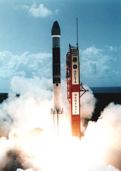
The Geotail satellite was designed and developed by ISAS, and it
was launched by NASA by DELTA II expendable launch vehicle on 24 July
1992. It includes scientific instruments provided by ISAS and NASA. The
satellite will be placed into the initial distant tail orbit for
approximately two and a half years; thereafter, it will be maneuvered to
a second orbit where it will operate for the remainder of it's lifetime.
Together with the Wind, Polar, SOHO and Cluster projects,
Geotail constitutes a cooperative scientific satellite project of
ISAS, NASA and the European Space Agency (ESA) designated the
International Solar-Terrestrial Physics (ISTP).
Program which aims at gaining improved understanding of the physics of
the solar terrestrial relations. The Space Research Institute (IKI) of
the former Soviet Union will also launch INTERBALL and
RELICT-2 satellites in the same time frame, and the entire program
is coordinated by the Inter Agency Consultative Group for Space Science
(IACG).
The ISAS Geotail instrument was formally decommissioned and powered down on 28 Nov 2022. Over 30 years after its launch.
The 30th Anniversary of the Launch of the Geotail Mission was 24 July 2022
The 10,000th day Anniversary of the Launch of the Geotail Mission was 9 Dec 2019
The 10,000th day of Geotail CPI data (HP & SW) collection was on 21 Feb 2020
Check out the January 2012 CME observed by the CPI Solar Wind Analyzer:
5 Days Surrounding Arrival,
Detailed Spectrogram, and
Moments.
Comprehensive Plasma Instrument (CPI)
CPI Instrument Documentation
HTML Documentation
for the Geotail CPI and the Survey Spectrograms is available
on-line. It can also be viewed in two other image formats:
Adobe PDF and
TeX DVI.
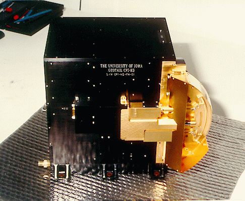
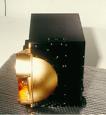
CPI Photo Gallery
- Two different views of the Hot Plasma/Solar Wind Analyzer Housing of the CPI flight instrument taken before its launch are the front and side view.
- A call-out diagram of the Geotail spacecraft and the instrument positions.
- Clean Room images of the assembled spacecraft with CPI visible in profile on the upper left.
- Clean Room images of the other sections of the assembled spacecraft: 2nd and 3rd.
- The final mating of the spacecraft and lower stages of the system in the clean room.
- The launch of the Delta II with Geotail from Cape Canaveral on 24 July 1992.
CPI Survey Data
Individual 5 Day Survey plots for both the Solar Wind and Hot Plasma
analyzers as well as a collection of monthly Geotail orbital
position plots are available:
The ISTP project has made a variety of interesting data periods available by
plotting "Key Parameter" data from several different instruments on the
Geotail spacecraft, including components from the CPI. These are
available for view from a graphical based WWW browser from the ISTP
Science Planning and Operations Facility (SPOF).
High Time Resolution Data
Hot Plasma high time resolution distributions are available by direct contact with the managing scientist,
Dr. Bill Paterson.
High time resolution plasma moments and 6-hour survey spectrograms are currently available below.
Solar Wind high time resolution distributions are available by direct
contact with the managing scientist,
Dr. Kent Ackerson.
High time resolution plasma moments are currently available below.
Related Topics
Last Modified: Monday, 22-Jul-2024 at 10:28:22 PM
This document has been accessed a total of 128,607 times.